Your cart
There are no more items in your cart
- dji ars madrid
- Blog - DJI ARS MADRID
- 0 likes
- 2555 views
- 0 comments

U10 LASER METHANE LEAKAGE DETECTOR
Product and solution
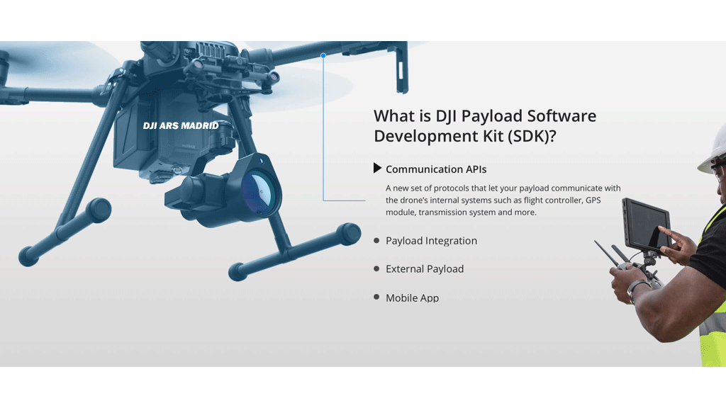
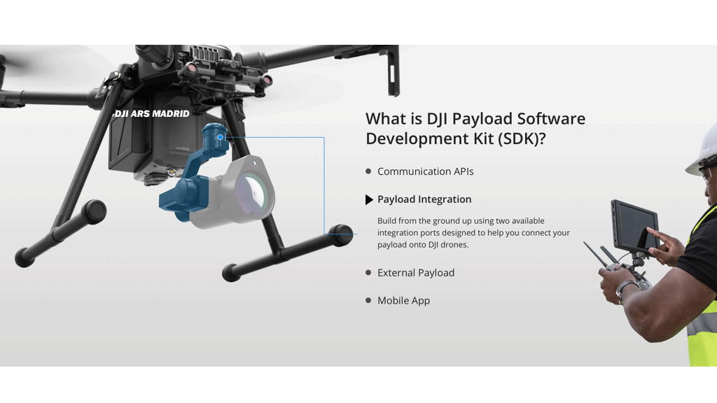
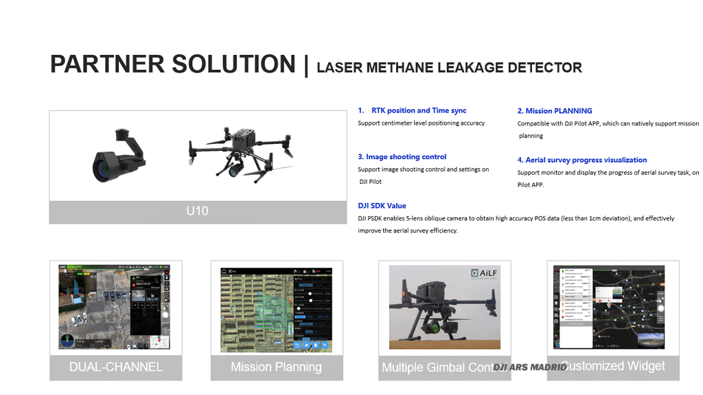
The U10 is a light-weight, high-sensitivity gas detector based on Tunable Diode Laser Absorption Spectroscopy (TDLAS), which enables rapid identification of methane from up to 100 m away, or at a concentration as low as 5ppm.m. Powered by DJI SkyPort, the U10 can be seamlessly integrated with DJI Matrice200 Series V1 and V2 platforms.

WINGSLANDZ15 GIMBAL SPOTLIGHT
Product and solution
1.Supports Dual Downward Gimbals
2.Strobe mode switch :Always on、18Hz strobe
3.Air Cooling System
4.Intelligent temperature protection
5.support DJI Pilot

PSDK102S FIVE-LENS AERIAL OBLIQUE CAMERA
Parnterintroduction
1. Committed to the development and production of UAV aerial survey and tilt camera.
2. Committed to the development of related software for drone tilt photography and aerial survey.
APPLICATIONS
Cadastral survey
Urban planning
Smart City
Real Estate Confirmation
Integrated premises and emergency command
Product and solution
1.Intelligent self-test: closed-loop detection when the camera is turned on with five angles of view
2.Active temperature control: built-in temperature control module, high temperature detection temperature, active heat dissipation.
3.Standard LOED screen: real-time display of camera status, flight control signal, number of photos in five angles, camera temperature and other information.
4.Down-view video transmission: supports real-time video transmission under HDMI, and can be connected to M210 series to realize dual-picture transmission.
5.Aircraft Unicom: Support the synchronization of the camera status and the M210 ground station information.
6.USB3.0 interface: Provide a faster transfer rate and improve efficiency.

LOUDSPEAKER
Product and solution
1.Data transmission is stable and flight safety is guaranteed
2.Online text to speech conversion
3.Background sound and broadcast content can be played simultaneously
4.Male voice, female voice, midrange, high pitch support independent choice
5.Support TF storage
6.Highly integrated, ready to use
7.Adjustable pitch angle
8.Safety protection, stable performance

SNIFFER4D V2 MULTI-GAS DETECTION SYSTEM
Product and solution
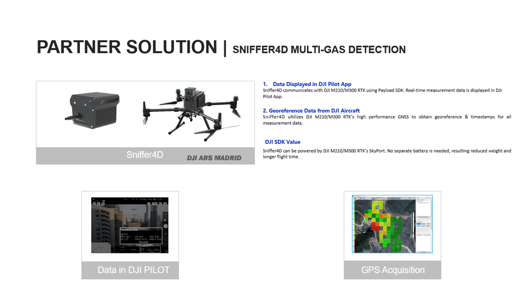
Sniffer4D is a complete drone-based multi-gas detection system which consists of a drone-mounted gas detection device and powerful analytic software. Sniffer4D is able to measure and visualize real-time gas concentration distribution, providing timely & actionable information for industries such as environmental protection, inspection and emergency response. Through DJI SkyPort, Sniffer4D can be seamlessly integrated with DJI M300 RTK and M210 series

ATMOSPHERIC POLLUTION DETECTION SYSTEM
Product and solution
1.It can detect up to 6 kinds of gases at the same time, using high-precision, high-sensitivity imported sensors, with an accuracy of ppb;
2.Based on PSDK development, using the SKYPORT interface, seamlessly docking with the DJI system, real-time transmission of flight data and inspection data;
3.Display the detection data on the visualized real-time map, including concentration value color change, curve change, raster map, etc.;
4.Historical records support visual analysis, including labeling on the map of monitoring points, concentration curve changes, average grid heat map changes, etc., and can be exported to Excel;

ATMOSPHERIC POLLUTION DETECTION SYSTEM
Product and solution
1. Real-time monitoring of multiple indicators in the air,
including PM2.5, PM10, CO, NO2, O3, VOCs, H2S, flammable
and explosive, etc.
2. Adopt the products up to the pipe pump + reaction chamber
to ensure the stability of the air flow during the flight
3. Able to collect gas samples while monitoring
4. Real-time mapping of pollution, one-click production
monitoring report
5. The command center can view monitoring video and air
quality parameters in real time
6. Deep integration of software and hardware with DJI aircraft,
support OSDK/PSDK+MSDK

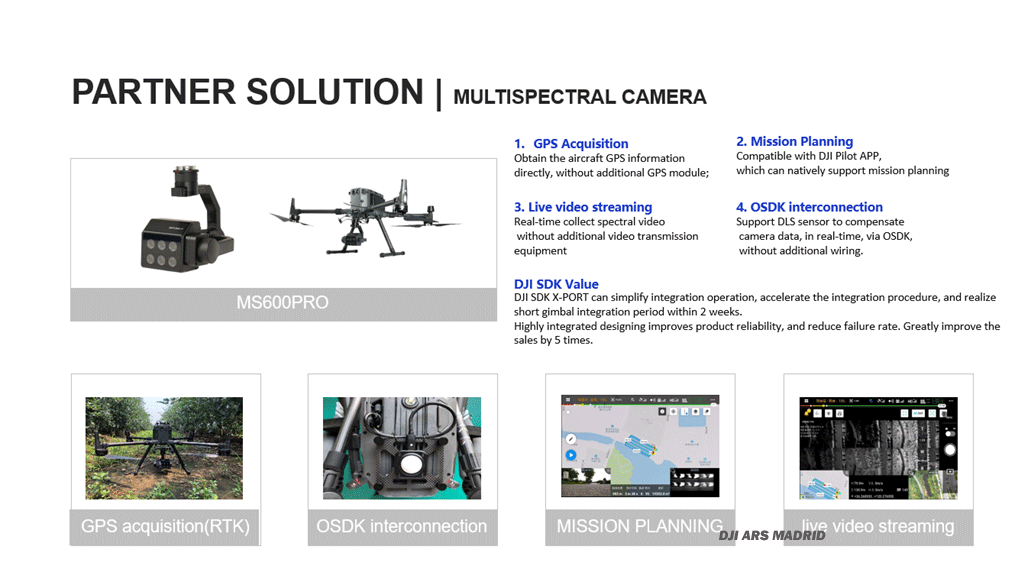
MS600PRO MULTISPECTRAL CAMERA
Product and solution
•6 band
•Calibration correction
•Real-time image transmission: data processing: support YusenseMap, Pix4D offline processing and "end-cloud integration"
•Synchronous data upload
•Storage/working temperature range: -30℃~+70℃/-10℃~+50℃
•Environmental adaptability: sapphire window, scratch-resistant, abrasion-resistant and durable

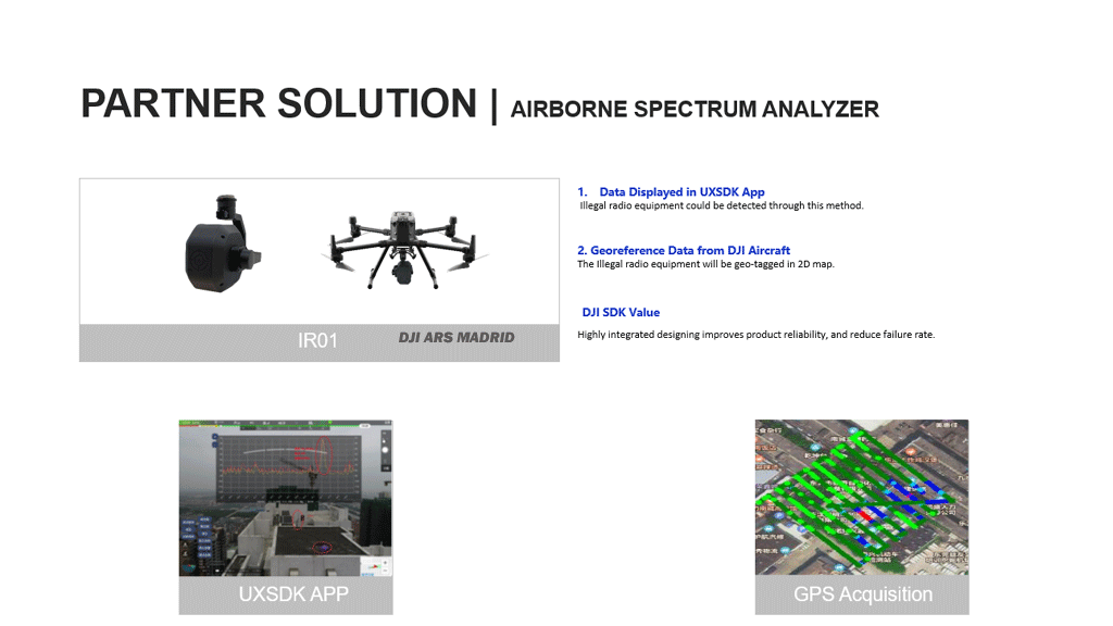
AIRBORNE SPECTRUM ANALYZER
Product and solution
1.Border and conventional area radiospectrummonitorandandManagement ;
2.Search, location, evidence collection and Law Enforcement Assistance of illegal broadcasting stations;
3.Testing and finding interference sources for mobile communication network;
4.Radio collar location tracking and outdoor rescue of wildlife;
5.Electronic countermeasure.

THERMAL CAMERA WITH 50MM LENS
Product and solution
1.50mm motorized lens, can shoot long-distance targets;
2.25Hz frame rate, suitable for high-speed target shooting;
3.Can record pictures and videos with temperature data;
4.Various temperature measurement methods, pointing temperature measurement and multi-zone temperature measurement;
5.Supporting special analysis software;

SINGLE-LINE LIDAR
Product and solution
1.Data is automatically associated with the tower
2.Automatic tracing of the wire and imitating sag flight
3.Fully autonomous obstacle avoidance
4.Real-time detection of wire defects and wire tree distance
5.Automatically generate defect analysis report

DUAL-CAMERA HD ZOOM AI GIMBAL CAMERA
Product and solution
1.Products developed for high-definition shooting and large zoom needs
2.Can shoot 20 million pixel high-definition pictures, 1080P video recording, maximum focal length 720mm
3.At the same time, it has a wide-angle field of view and a zoom field of view for easy target positioning
4.Built-in high-performance processor, can identify more than 19 types of power transmission line tower targets, complete automatic shooting of power inspection
5.Support OSDK automatic flight control, you can connect M210 through the gimbal camera for OSDK flight
6.Supporting APP developed by MSDK, can perform manual flight and automatic flight
7.Supporting laser point cloud processing software, can plan autonomous flight routes based on .laspoint cloud, and import APP

VECTOR FIVE-LENS AERIAL OBLIQUE CAMERA
Product and solution
1.It can be mounted seamlessly with M200/M210 and has high integration, portability, ease of use and safety.
2.The weight of the camera is less than 510g, and the pixels are about 50 million. It is equipped with a USB interface and supports direct export of photos + GPS information.
3.Adopting the binocular tilt measurement program, combined with the original perspective cross and side overlap technology, can achieve high-precision three-dimensional real-world modeling and large-scale map data production.
4.The self-developed Wing ground station App can realize polygonal route planning, one-key take-off, automatic return, and breakpoint continuous flight.

LIAIR V UAV LIDAR SCANNING SYSTEM
Product and solution
The LiAirV series is a light and small lidarpoint cloud data acquisition system independently developed by Digital Green Valley(integrated with LivoxMid-40 laser, based on a limited field of view of 38.4°), and can be mounted on M600 (weight 2.8kg), M200 ( Weight 1.3kg) and other flying platforms. The product incorporates digital green earth cloud trace technology, supports a base-less operation mode, and works with LiPlan, LiCloud, LiDAR360, LiPowerlineand other series of software, which can provide data collection, processing analysis, and customized reports for forestry investigation, topographic mapping, and power inspection users Wait for a one-stop solution.

FOUR IN ONE CORONA CAMERA
Product and solution
it is a combination of UV, infrared, visible light, and laser range finder. It works on DJI enterprise platforms to help discover the potential safety hazards of insulator in time. With the 1: 1 UV and IR synchronous display, the detection of corona and heating can be done simultaneously. Defect identification function can be developed on the powerful built-in processor.

PD4 POWER DROP KIT
Product and solution
PD4 is installed on the Drone of DJI M300RTK. It is able to carry diverse
loads and release them to the specific areas. The staff can monitor the live
view of scenario while delivering the loads remotely to help with the
emergency rescue tasks.
PD4 is applicable to occasions where relief supplies should be delivered
urgently. The airdrop can deliver them quickly and easily when they are
difficult to reach.

Comments (0)